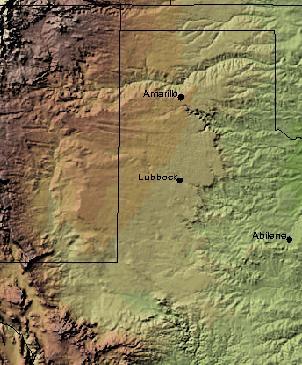
This afternoon’s monthly geography-based #GenChat is about the Great American Desert. Now,

geographically-speaking, this could mean slightly different parts of the panhandle region of Texas, or it could mean a different part of the state.
Originally, in the 19th century, according to Wikipedia, the term referred to the western part of the Great Plains which extend to the 100th Meridian. And the 100th Meridian is what determines the border between Texas and Oklahoma up in the panhandle region of Texas. So, if you were to use this definition of the Great American Desert from this time period in looking for records, you’d need to consider pretty much all of the counties in our panhandle. Here is a list of the counties from as well as general information about the Texas Panhandle from Wikipedia.
However, the term evolved later to mean the High Plains which would then include the Llano Estacado plains area of Texas up in our panhandle and could encompass up to 39 Texas counties depending on which source you consult, but they definitely do not stretch to the 100th Meridian, but they do stretch a little further south of what is considered the panhandle in Texas. The list of counties included in the Llano Estacado plain area are listed here on Wikipedia.
To complicate matters, some have also used the term “Great American Desert” to refer to desert areas (arid) in general or areas that seemed desert-like (semi-arid). The northern part of the largest North American desert, the Chihuahuan Desert, spills into the western part of Texas, west of the Pecos River, known as the Trans-Pecos region of Texas. While not truly arid, this semi-arid region certainly looks very desert-like. It encompasses 9 counties in Texas which are listed for you in Wikipedia.
Knowing what counties or areas your Texas ancestors lived in will help you to zero in on libraries, archives, research centers, genealogical societies, and online — as well as offline — catalogs and indexes to search in for more information.
Also, for help in identifying which genealogical societies to contact, you can use our clickable District Map to find a society in the correct area you are interested in. You might find our Partner Society Listing helpful as well.
And join us this afternoon on Twitter as we participate in #GenChat — The Great American Desert at 3pm CDT.
- 10 Questions To Ask Your Relatives To Help Build Your Family Tree - November 10, 2014
- Congratulations To All the 2014 TSGS Award Recipients! - November 10, 2014
- TSGS 2014 Conference and Awards Update - August 6, 2014

